Having recuperated from the week long trek from Jiri to Namche Bazaar we bid steak dinners and apple pie farewell and continued our ascent into the Everest region. We listened to the peaceful chants of Buddhist monks at the Tengboche monastery. We enjoyed our own private guest house, for lack of other guests, in Orsho at 4,000m – 13,300ft.
It began to snow on our third day (10th from Jiri). It was only a dusting, less than an inch, but it made every surface of the Imja valley glitter. We climbed into the beautiful village of Chukung. From here the massive Island Peak (Imja Tse) dominates the skyline. It is only a two day climb to the summit and I agonized over spending an extra $800 for permits and equipment climb it. I was, however, appalled at the poor physical fitness and lack of experience of paying customers and their guides, who’s quality seemed equally dubious. I opted out of an attempt on Island Peak and climbed Chukung Ri, an easy walk by comparison but only 600m – 2,000ft lower, with Val and left the $800 in my wallet. Maybe next trip…
 From 5,550m – 18,205ft above sea level atop Chukung Ri the icy wall of Lhotse rises almost vertically 3,000m – 10,000ft dead ahead. Lhotse is the fourth tallest mountain in the world and seeing it so close was humbling. Makalu, the world’s fifth highest, and Ama Dablam, Nepal’s most beautiful mountain, also seemed close enough to reach out and touch. Neither of us felt any altitude related symptoms, a great relief to me. Val was up there solely because of me, she is a brilliant scuba diver, an activity that also requires a tolerance for low oxygen intake, so I expected she would perform well at high altitude, but until now it had only been a guess. This meant no trek in Nepal was off limits for us – once again Val proved to be a kick ass travel companion.
We skipped the first of the three passes. I’d gathered from a half dozen previous parties that Kongma La was the hardest of the three passes. What gave me doubts was that the view was reported to be nice, but not unmissable. I have no problem with a bit of hard work, but doing something hard for the sake of it being hard? The decision was clinched when an old Himalayan veteran mentioned the route around the pass is one of the most beautiful stretches of trail in the entire Everest region. Our knees thanked us and our eyes drank in the tremendous views of Ama Dablam, Taboche, and Cholatse above us and the village of Periche and beautiful lakes below us.
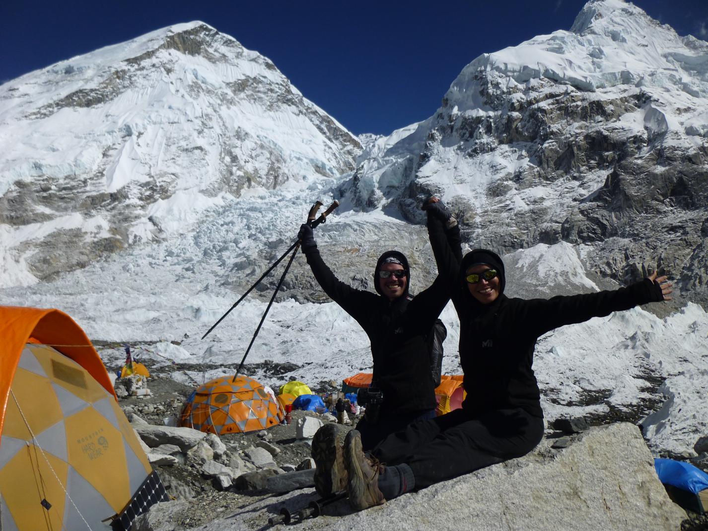
The trail then turned and climbed to Everest Base Camp and Kala Pataar. Most parties stop at a little plastic banner that says “Welcome to Everest Base Camp!” You can see the real base camp a half kilometer further on. We laughed at the tourist hordes and walked to the real thing. There were two expeditions attempting a winter ascent, neither would prove successful (but we were hopeful for them at the time!). The Khumbu Icefall, a malignant waterfall of empire state building size blocks of ice, loomed directly above us. It looked utterly suicidal that anyone would attempt to walk through that part of the Khumbu Glacier but indeed anyone who climbs Everest from the Nepal side (85%) must brave the Khumbu Icefall at least four times. Each expedition has special porters who’s sole responsibility it is to ferry loads through the icefall. More of these porters are killed than climbers on the upper mountain. Indeed Val found the lower half of a human arm lying on a rock near base camp, spit out by the glacier.
 Kala Pataar is a nearby hill offering one of the world’s preeminent mountain vistas. I could go into superlatives about the experience but I will let the pictures speak for the themselves instead. Most people spend a half an hour or less at the top. We spent half a day – watching the mountains stay perfectly still while people came and went. I thought of my father, whom instilled a love of nature in me early in life and whom I desperately wished was with me to share this moment.
Next we backtracked down the valley and began our ascent of the Cho La pass. We crossed a snowy glacier, which Val loved, and even had to do a bit of rock climbing to reach the pass. Again we lingered longer than everyone else, watching trekkers come and go. A few cried, you could tell this was the hardest physical task they had ever completed, they hugged spouses and friends. The atmosphere was festive.
The path down the Cho La entails a 1,600m – 5,280ft descent over loose scree (think gravel). I had a great time with an Indian man and his porter, singing, running, and occasionally falling but laughing all the while. Val moved at a more conservative pace with another, similarly more reasonable, Indian tourist. We went on for hours finally reaching a massive flat lacier. The word apocalypse came to mind as we followed the path onto it. The ice here is covered by a thick layer of pulverised rock. The path constantly changes the landscape shifts with the ice. Lakes, waterfalls and landslides are strewn in a chaotic mess. We just wanted to get through as fast as possible. We could hear the glacier creaking and rocks falling all the time. It took an hour to reach safety and come upon the village of Gokyo.
Gokyo is the largest of the high settlements in the Everest region. Its set on a large lake below a cirque of small peaks. Yaks graze on the rich grasses, providing fuel for the town. A half a days walk leads further up the valley led us to more lakes and views of both Mt. Everest and Cho Oyu, the world’s sixth tallest mountain. At the top of Gokyo Ri we could see four of earth’s tallest mountains and countless smaller peaks, the ugly gash of glacier we had crossed a contrast to the sublimely sculpted masterpieces above it.
 Renjo La, the last of the three passes, is perhaps the most beautiful. It offers the most all encompassing view on the entire trek with Everest appearing in it’s true scale, much larger than everything else around it. Seeing it was slightly bittersweet. From this point on we were headed “back”. We felt privileged to be in one of the most spectacular natural settings on earth and it was sad to feel our time running out.
Two days further down we entered Chame, a lovely village of yak pastures. stone lodges, and Buddhist monasteries. We were treated to our second sunset of the month – it had been cloudy from the afternoon onwards all our other days. In Namche we enjoyed our first shower in two weeks – it was a welcome change.
I had initially worried that Valerie might not like trekking so I was startled at her her surprise when I told her we would fly out. She wanted to walk another hard week out to the road! My feet were cracked and bleeding and a flight in or out of Lukla is a right of passage, so in the end it was me who caved and took the easy way out. Isn’t life ironic? Who’s the tough one now?


What do you think? Leave me a comment.